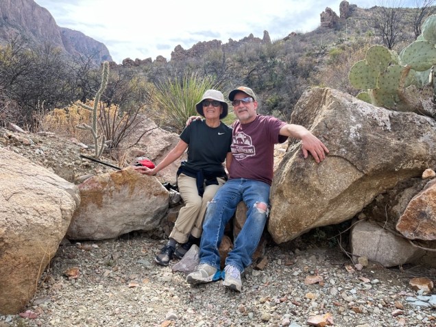
 For many years, every winter my sons and I have gone on a week-long ski trip, usually with the local ski club. Often it was the only time all three of us got together. Since I’ve stopped skiing, I’ve tried to replace this annual event with a hiking trip. Last year we went to Tucson, AZ to visit and hike with my brother. This year we decided to join a small group of ski-club friends who were going to Big Bend National Park. As it turned out, there were a few ups and downs to this memorable trip.
Some early setbacks
We were planning to be in two rentals within walking distance in Lajitas, TX ; my sons and I in a small house and the rest of the group nearby in a larger one. Because of scheduling conflicts, their group shrunk and they downsized to a smaller house several miles away in Terlingua. And then, my son David could not join us. He had to cancel right before we left. Although he made the right decision, we were all disappointed. Another downer was the recent drought. The desert was NOT in bloom; river beds were low or dry; the landscape almost monochromatic, more sepia than Kodachrome.
It’s big (really big) and remote
Right off, I thought the park is misnamed. It should be called Ginormous Bend National Park. It’s only the 7th largest national park, yet it felt boundless. Being so remote added to that perception. The amount of driving we did in one week—1000 miles—was notable. We flew into El Paso, rented a Jeep Wrangler, and drove over 5 hours to get there, with just a short stop in Alpine for groceries. One surprise was the Border Patrol checkpoint between El Paso and the park. I guess we didn’t look suspicious; we were waved right through.
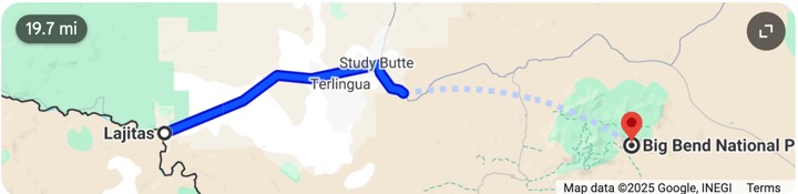
 The distance from Lajitas to the park entrance, plus the back-and-forth between our houses for shared meals, added to the drive time. And, once you actually got into the park, the trip from our Maverick Junction entrance to many of the trails can take an hour. My son Eric cheerfully did all the driving and I was very grateful.
So many hikes, so little time!
The park has every kind of hike you could want, from simple walks to mountainous hikes with sizable elevation. There are 150 miles of hiking on 80 trails, not counting backpacking choices. While we did not accomplish everything on our ambitious wish list—we never got to the Chisos Mountains—we did cover a lot of ground.
Ward Spring Trail
Day 1: We started the week with this easy 1.6-mile hike across open ground, giving us long distance views of the mountains and smaller peaks. Ward Spring was advertised to be a small but permanent water source along upper Cottonwood Creek in an area with abundant plant life and wildflowers.


Unfortunately, because of the dry spell, we had to use our imaginations. What we encountered was a damp spot in parched, rocky, and lifeless terrain.
The best part was the free, random reflexology I got through my soft soled sneakers. (I switched to a sturdier pair the next day!)
Chimneys Trail and Castolon Historic District
Day 2: Chimneys Trail was a longer and more interesting hike, almost 5 miles out and back, to tall outcroppings or “chimneys” spread along the desert floor. To the left was a standalone chimney decorated with carved petroglyphs and painted pictographs created by the indigenous people between 3,000 and 8,500 years ago. To the right, was a series of connected formations, including the iconic “window”.


On the way back, we stopped for a cultural moment at the Castolon Historic District. A remnant of Big Bend’s pioneer and military history, the area reflects the early-20th entury farming and trading community that included a U.S. Army outpost and a cross-cultural mix of Spanish, indigenous peoples, and Anglo-American settlers.
From 1922-1942, the La Harmonia Company actually grew cotton here! Some of the equipment remains as Instagram-worthy, rusted artifacts.


Santa Elena Canyon
Day 3: The Santa Elena Canyon hike was one of my favorites. We had to wade across the Rio Grande River to get to the trail. Our choices were to get our shoes wet or go barefoot. The river was not deep, but the rocks were slippery and hard on your feet. There were a few gasps and giggles….and no one fell in! (Sorry. No pictures…too risky to take my camera out!) The trail on the other side offered comforting shade, some bird activity, and stunning views.
Lower Burro Mesa Pouroff
 Afterward, we went to Lower Burro Mesa Pouroff, walking about a mile through a gravel wash. I learned that a “pouroff” is an eroded stone column caused by water falling from the cliff above.
At 100 feet tall and completely dry, this one looked like a waterfall without the water. I waved to people, barely visible, way up on top at Upper Burro Mesa Pouroff. Maybe a hike for another day?
Exploring Terlingua
Day 4: Some of us took a day off from hiking to explore the Terlingua area, which my friend Rob appropriately described in his blog as “hardscrabble”. We poked around in some rock shops and art studios, after realizing that any trailer, shanty, or run-down looking building could be a place of business. One rock store was closed, but you could pick stones from the trays outside, weigh them, and leave the money under the door!


We also visited the local Ghost Town tourist attraction. What was once the Chisos Mining Company now features the Terlingua Trading Company selling regional arts and crafts in an ancient building, the Starlight Theatre resurrected as a restaurant and bar, the old jail that now houses restrooms, the historic Terlingua cemetery, and ruins of the original homes.


Sam Nail Ranch, Fossil Exhibit, and off-road adventure
Day 5: The abandoned Sam Nail Ranch, located in what is considered a desert oasis, was started at the end of WWI by Jim and Sam Nail. It originally had fruit trees, a garden, cattle, horses, sheep, and goats. It now has some welcome shade, the spooky relics of buildings, and an old windmill that is still functioning.


Second stop was the Fossil Exhibit at Panther Junction. This modern, museum-worthy presentation of Big Bend’s ancient life, roughly 130 million years of geologic time, is geared for both adults and children. I took the short climb to an area where you can take in a wide vista of the monochromatic, volcanic landscape captured in this video.


From here, we went on Mr. Toad’s Wild Ride, Texas style!
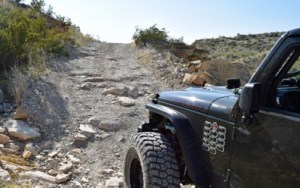 We were heading to the Rio Grande Village on the far side of the park and took Old Ore Road. The Park Service website says it is a primitive road in very poor, unmaintained condition, requiring high clearance and true 4-wheel drive vehicles. Our jeeps qualified, so off we went. I guess going off-road must be a “guy-thing”. The road is 26 miles long, our top speed was 10 mph. This made for a very long, uncomfortable ride with a few (for me) frightening moments. We got to the village too late to hike. Bummer. We used the restrooms and turned right around to head home, thankfully on a paved road!
Big Bend Ranch State Park
Day 6: On our last day we went to Big Bend’s other park, Big Bend Ranch State Park. It is the largest state park in Texas, yet 1/3 the size of its ginormous neighbor, and was originally a cattle ranch. We had beautiful weather to enjoy two short hikes. We followed the Hoodoos Trail 1-mile loop past big rock formations, along the bank of the Rio Grande, to a scenic overlook, and back. The Closed Canyon trail took us 1.4-miles out-and-back on very different terrain through a slot canyon, where we carefully made our way around tinajas (rock pools) to the dead-end point before returning.


Some extras
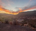 We loved our VRBO in Lajitas. It was clean, spacious, and well-equipped and within walking distance to the Lajitas Golf Course Resort. With its upscale dining, a general store, and a handy café., it was a spot of luxury in the desolate landscape. And, watching the sunset over the mountains from our front porch was a great way to end the day.
Every trip is an opportunity to learn. Beside the geology (pouroffs, tinajas) and geography, Big Bend and the surrounding area gave a me a glimpse into, and appreciation of, the hardship and struggle in the grand expanse of the west Texan desert. Mines, ranches, homesteads, cotton fields…who knew? With Mexico just across the river, I was curious about that relationship and found that Mexicans were the earliest settlers, although their history and contributions are often overlooked. To wit, the oldest known adobe structure still standing in the park was a small store owned by Cipriano Hernandez.
Find out more

I’ve never even heard of these places! You are such a studette…Thanks for sharing.
LikeLiked by 1 person